WHO INVENTED
UKRAINE?

For 400 years, our dangerous neighbor — Muscovy, which later appropriated the name ‘Russia’ — tried to rewrite history and erase even the idea of an independent Ukraine.
Ukraine Terra Cosaccorum is not just a collection of ancient artifacts. It is direct evidence that Ukraine is the land of the Cossacks — with its own history, identity, and place on the map of Europe for many centuries.
This project was created to dispel once and for all the myth that ‘Ukraine was created by Lenin’ in the 1920s. Maps, documents, books, and artifacts speak louder than words. They reveal the true Ukraine — the one Europe had known for many centuries.
_edited.png)

ANDRY
SLABINSKY
My name is
My interest in Ukraine’s living history began during my studies at the Kyiv-Mohyla Academy - the oldest university in Eastern Europe.
For over 15 years, I’ve been acquiring rare historical artifacts at international auctions. These items allow us to see Ukraine as it truly was: independent, unique, and dignified. I pursue this mission out of deep respect for the past and a desire to help us rediscover Ukarine's true self.
This project is my personal contribution to restoring historical justice. I believe that when Ukrainians know their real history, they become stronger.
Each artifact in this collection is a fragment of a larger mosaic - the mosaic of Ukrainian (and European!) memory
collection value
We have gathered legendary artifacts that prove Ukraine has been present on the map of Europe for over 400 years - and never disappeared from it.
Now, anyone can see this for themselves - right here, online.
These rare books and historical documents clearly debunk the widespread myths spread by Russian propaganda.
This collection is a source of undeniable facts that help the world better understand Ukraine as an essential and long-standing part of European history and culture.
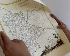
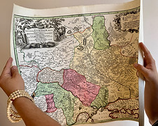
Antique Map of Ukraine, 1720
Ukrania quae et Terra Cosaccorum
Original Latin title: Ukrania quae et Terra Cosaccorum cum vicinis Walachiae, Moldoviae


Year of publication:
Around 1720
Place of publication:
Nuremberg, Germany
Author:
Johann Baptist Homann (1664–1724)
Size:
55 x 64 cm
Provenance:
purchased from Private collection in Nuremberg, Germany
Artifact Category:
Antique map of Ukraine, 18th century
Historical Significance
Artistic Value
Description
Condition
One of the most famous maps of Ukraine from the early 18th century.
This legendary map was created over 300 years ago in Germany by the renowned cartographer Johann Baptist Homann.
The territory is clearly marked as “Ukrania – Land of the Cossacks”.
This proves that Ukraine was recognized as a Cossack state and known across Europe.
The map is an important piece of evidence showing that Ukrainian identity was already formed several centuries ago.
It refutes modern Russian propaganda myths claiming Ukraine was "created by Lenin" in the 1920s.
This historic map is not only accurate — it’s visually stunning.
Created in the refined coloured engraving style of the 18th century, it has preserved its vivid original tones.
The detailing of rivers, towns, and trade routes is remarkable, with elegant Latin inscriptions.
A baroque-style decorative cartouche features Cossacks and symbolic figures representing military strength and Ukraine’s cultural uniqueness.
Thanks to these elements, the map is both a historical document and a piece of art.
A rare original copperplate engraving, printed and coloured by hand over 300 years ago in Germany.
Created by Johann Baptist Homann, one of the leading European cartographers of the 18th century.
One of the earliest maps where Ukraine is clearly labeled as “Land of the Cossacks” (Terra Cosaccorum).
Also depicts Moscovia, Wallachia and Moldova.
The map reflects Ukraine’s cultural and geographical identity, highlighting its uniqueness.
This specimen is in excellent collectible condition.
Colours are vibrant and clear. The paper retains its original texture.
It fully conveys the artistic beauty and engraving mastery of the 18th century
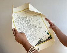
Antique map of Ukraine from 1740 Amplissima Ucraniae Regio
Original title: The widest region of Ukraine covering the Kyiv and Braclav Counties


Year of publication:
Around 1740
Place of publication:
Augsburg, Germany
Author:
Matthäus Seutter (1678–1757)
Size:
50 x 59 см
Provenance:
purchased at Winterberg Kunst auction (Germany)
Artifact Category:
Antique map of Ukraine, 18th century
Historical Significance
Artistic Value
This antique map of Ukraine was created around 1740 in Augsburg by the famous German cartographer Matthäus Seutter, who was the official cartographer of the Holy Roman Emperor.
The map focuses on the Kyiv and Braclav regions, shown here as the “widest region of Ukraine.”
It’s one of the most detailed European maps of the 18th century and shows that people in Europe clearly understood where Ukrainian lands were and how they were structured.
This map helps us understand the roots of Ukrainian identity and how the nation was seen at that time.
The map Amplissima Ucraniae Regio stands out thanks to its beauty and attention to detail. It was made using the best techniques of 18th-century German mapmakers. The colors are vivid, and the lines are very clear.
One of the most eye-catching parts is the decorative cartouche in the top corner. It shows people, animals, and objects that represent power, nature, and life in Ukraine at the time.
The borders, rivers, roads, and cities are all drawn with great care. These details help us feel what life was like in Ukrainian lands almost 300 years ago.
Description
Condition
The map was made using the copperplate engraving method — it was engraved on a copper sheet and then partly hand-colored.
This method allowed for high precision but produced only a limited number of copies. Usually, no more than 100–300 high-quality prints were made. After that, the copper plate would lose sharpness and couldn't be used anymore.
This original copy of the Amplissima Ucraniae Regio map is in very good collectible condition, especially considering its age of nearly 300 years.
It is printed on laid paper (a typical 18th-century paper with a textured grid) and partly colored by hand.
The visual quality is excellent: the colors are still bright, and the printed lines are clear.
The map has a flattened center fold with slight signs of past folding. The lower edge shows some faint water marks and tiny edge tears, which are common for maps of this age.
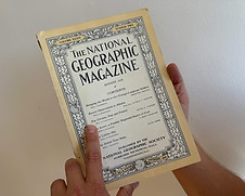
The National Geographic Magazine (1918)


Year of publication:
August 1918
Place of publication:
Washington, D.C., National Geographic Society
Author:
Nevin O. Winter. Text and original photographs.
Historical Significance
Artistic Value
Description
Size:
Ukraine feature spans 15 pages with photos (pp. 114–128). Approx. magazine size 18 x 25 cm.
Провенанс:
Велика Британія / приватна колекція
Категорія артефакта:
Раритетне періодичне видання. Українські студії початку ХХ ст.
This is the first substantial international feature about Ukraine and Ukrainians in a leading global magazine. It presents Ukraine as a distinct people and land. It records the names Kyiv, Kharkiv, Odesa, Galicia, Crimea, and the term Ukraine. The issue appeared as the world acknowledged the Ukrainian People’s Republic. The article counters modern myths about the “late” origin of Ukrainian identity. It is direct evidence of Western attention to Ukraine in 1918.
Classic National Geographic cover with ornate border. High quality gravure photographs from Kyiv, Kharkiv, Odesa, and the Ukrainian steppe. Genuine reportage style. Original early 20th century advertisement preserved on the back cover.
Original collectible copy. Clean paper, complete cover, firm spine. All pages present. The issue includes “The Ukraine, Past and Present” with the author’s photographs. Other wartime features add context to the period.
Other exhibits


Interesting articles

